ViewRanger vs Garmin – I was wrong
In April 2017, faced with the news that ViewRanger was introducing a new social feed that could not be deactivated, I wrote this somewhat angry post explaining why I hated the idea. But fast-forward two months, and my position has softened. I thought I’d be able to replace ViewRanger with a mapping Garmin handheld. It turns out that this isn’t feasible for my needs.
The problem
I urge you to read my original post for the background on why I think there’s a problem here. In summary:
- An update to ViewRanger introduced a new social feed to an app that had previously been focused 100% on precision digital outdoor navigation.
- I was concerned about app bloat, slower loading times, invisible data use and – most importantly – user distraction. I have a bit of a thing about social media muscling in to places where it doesn’t belong, and I saw this as an example of an important utility trying to become a social network.
My solution, and how it turned out
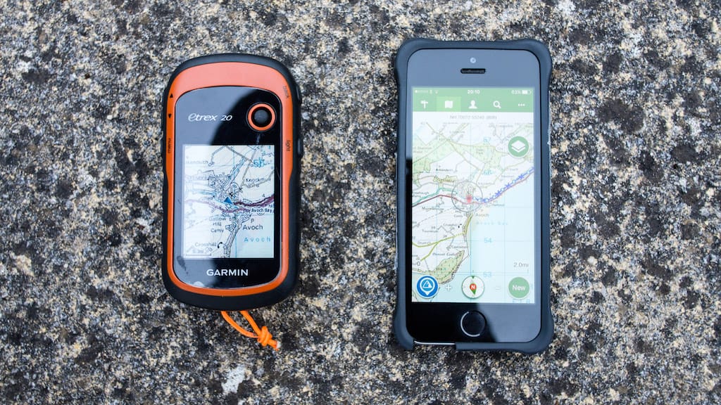
My attempted solution was to switch to a mapping Garmin GPS handset, specifically an eTrex 20.
I love Garmin devices. They’re compact, reliable, run on AA (or AAA) cells, and have a truly excellent trip computer screen that gives you a constant readout of critical data such as trip distance, altitude, trip time etc (totally customisable).
My idea was to completely replace all the functions I used to use ViewRanger for with this eTrex 20. What I have learned over about 10 trail days using the new setup is that the eTrex 20 is not a complete VR replacement for my needs – although it does some things much better, there are other things that I still need ViewRanger for, and I found myself gravitating back to the trusty nav app despite my opposition to the social feed.
Here are the advantages of an eTrex over an iPhone running ViewRanger:
- Heroic battery life. Using a pair of Lithium AA cells, it can run for something like 40-50 continuous hours with the screen on, including full GPS tracking. That’s an order of magnitude better than any smartphone ever made. For this reason, it’s significantly better for recording a GPX track – something I’m not comfortable using ViewRanger for on a long trip, due to battery concerns.
- The screen is easily readable in sunlight without switching the backlight on. This saves even more power.
- It’s operated entirely with buttons, which is a lot less fiddly when wearing gloves.
- Very rugged. The screen has a clear plastic shield over it, making it impervious to all but the worst drops.
- Waterproof and resistant to sub-freezing temperatures.
- It has an offline 1:50,000 Ordnance Survey map on a memory card – covering the entire UK.
- Transferring data to and from the device is completely offline and doesn’t go anywhere near the cloud.
But for all its benefits – and they are pretty huge – I still found myself using ViewRanger sometimes as well. Here’s why:
- The eTrex has a small, low-resolution display, and a very slow processor. While it’s great at showing you where you are right now, it’s pretty bad for panning and zooming around, getting the bigger picture. ViewRanger has a significantly better map-viewing experience on just about any smartphone hardware.
- It’s much more difficult to plan a route directly on the device than it is with ViewRanger. Garmin route planning is best done on a desktop computer and then transferred to the handset. While this is fine most of the time, sometimes you need to plan a new route while you’re actually on the hill. The Garmin’s support for this is very crude.
- You can add any maps you like to ViewRanger, over an internet connection. If you want to add 1:25,000 map tiles, you can do so affordably. 1:25,000 OS mapping is very expensive on Garmin.
- Because the eTrex is completely offline, there’s no way of getting the GPX file out of it and onto the web (or wherever) unless you can plug it in to a computer.
In practice, I’ve found that the eTrex and ViewRanger are simply good at different things. The eTrex is excellent for keeping on all the time to track your route and quickly see where you are, but ViewRanger is a much better paper map replacement. The ability to easily pan and zoom the map is a huge advantage that I hadn’t fully appreciated before. The eTrex’s slower processor and small, grainy screen just can’t keep up.
U-turn
In my previous ViewRanger post, I made a rather black-and-white statement:
Let me switch off these features and I’ll be happy. But I refuse to use a navigation app that forces me to participate in yet another intrusive, attention-hungry social network – I find the existing social networks I participate in exhausting enough as it is. ViewRanger may be the best in its class, but if it continues down this path then I will stop using it.
While I’m still not thrilled about the social feed, in practice I have found it easy enough to ignore. I’d still prefer the ability to remove the SkyLine button from the main display too. But I am not going to stop using ViewRanger – it’s just too good at what it does, and restricting myself to a Garmin handset is an inferior experience. I will be using the Garmin in winter, on trips where I expect bad weather, or where I need continuous tracking, but ViewRanger will be more than sufficient the rest of the time.

Alex Roddie Newsletter
Subscribe here to receive my occasional personal newsletter in your inbox. (For the fun stuff, please consider subscribing to Alpenglow Journal instead!)